| Home | > | List of locations | > | Nyika National Park, Malawi |
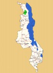
Location: Nyika National Park, Malawi
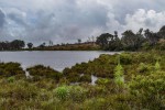
Photo: Bart Wursten
View to Nganda Hill with typical montane Nyika landscape of rolling grasslands with small patches of evergreen forest.
General Information
Quarter degree square: 1033B4, 1033D1-4 and smaller parts in 1033B3, 1034A3 & 1034C1 Country: Malawi Habitat: Montane grasslands, rocky areas, subalpine vegetation, (sub) montane evergreen forest, woodland, exotic plantations, dams and streams. Altitude range: c. 1650 - 2607 m Annual rainfall: Location (short): Large montane plateau in northern Malawi and a small area in adjacent Zambia Location (detailed): A small western portion of the upper plateau lies across the border in Zambia and has also been designated as a national Park by that country under the same name: Nyika National Park, Zambia. |
Description
Nyika National Park is Malawi’s largest national park covering an area of 3200 km². The park was first established in 1966 and extended in 1978.
For more information see Wikipedia.
Useful links
View a list of records for Nyika National Park, Malawi
View a list of unique taxa (excluding cultivated plants) for Nyika National Park, Malawi
View a list of unique taxa (all taxa whether cultivated or not) for Nyika National Park, Malawi
View a list of recorders who have visited this location
| Home | > | List of locations | > | Nyika National Park, Malawi |


